- Applications
- Tools
Coordinate Converter
| Install | 450 |
| From 1 Rates | 5 |
| Category | Tools |
| Size | 27 MB |
| Last Update | 2025 October 8 |
| Install | 450 |
| From 1 Rates | 5 |
| Category | Tools |
| Size | 27 MB |
| Last Update | 2025 October 8 |
Images


Introduction
1. Accuracy and Validation
Comprehensive range validation:
Latitude: -90° to +90°
Longitude: -180° to +180°
UTM Zone: 1 to 60
UTM X: 160,000 to 840,000 meters
Complete error control system
Clear error notifications and user guidance
2. Output Capabilities
Multiple format support:
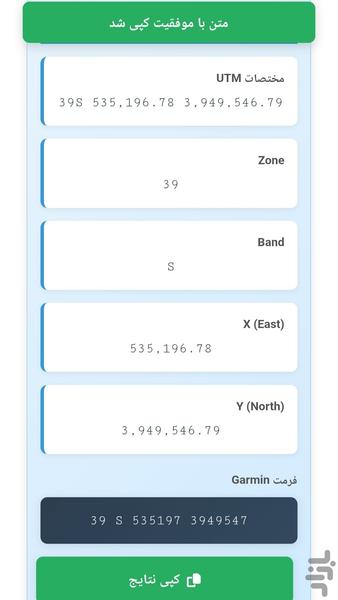
Complete UTM coordinates
Separate values (Zone, Band, X, Y)
Garmin-compatible format
Decimal degrees
Degrees-Minutes-Seconds (DMS)
3. Optimized User Experience
Interactive tab design for easy navigation
Progressive results display with auto-scroll
Automatic copy-to-clipboard functionality
Computational Algorithms
Full implementation of standard UTM algorithms
Accurate conversion to Degrees-Minutes-Seconds
Precise central meridian calculation
Practical Applications
Field Applications:
Surveying and Geodesy
Navigation systems (GPS)
Environmental studies
Construction and infrastructure projects
Technical Applications:
Spatial data conversion between different systems
Data preparation for GIS software
Coordinate accuracy verification
System Advantages
High Precision: Utilizes precise WGS84 parameters with 0.01 meter accuracy
Optimal Efficiency: Fast processing and offline functionality
Reliability: Comprehensive input validation and complete error management