- Applications
- Tools
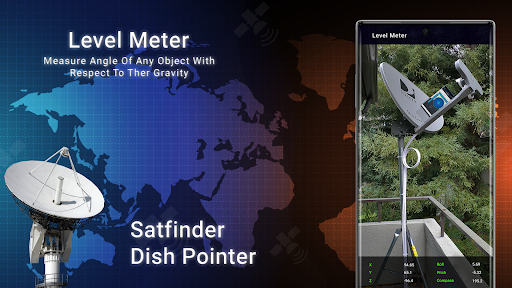
Satellite Finder Director: GPS
| Install | 99 K |
| From 91 Rates | 3.7 |
| Category | Tools |
| Size | 21 MB |
| Last Update | 2025 July 5 |
| Install | 99 K |
| From 91 Rates | 3.7 |
| Category | Tools |
| Size | 21 MB |
| Last Update | 2025 July 5 |
Images


Introduction
🔥Satellite Finder & Dish Anywhere is a helpful Dish TV signal Meterfor all satellites. Find the Satellite Director and Antenna Signal Finder the accurate azimuth and elevation in the Satellite Tracker online for all television. You can TV Antenna Station Finder selected to different countries with the Satellite Pointer & Speedometer App for Android. Use the Satellite Map on your phone and enter the Area, select the Dish name on the Satellite Position Finder, and select the country on your device.🔥
🛰️Our Satellite Finder Map makes a difference in aligning your dish. According to your area and the chosen satellite the Sat Finder App shows you the level and vertical position through which you have to set the direction of your Satellite Dish.
🧭 Satellite Compass with accuracy value like Satellite Finder 2024 our direction and distance to any place around the world. The Dish TV Signal Check Meter set the Compass in Dish Alignment according to direction of our phone until accuracy reaches high level.🔥
🚀Main Feature of Satellite Finder & Dish Pointer🚀
⭐Satfinder dish pointer helps pinpoint the current location of satellites.
⭐The Compass offers real-time guidance in any direction.
⭐Inclinometer is used for earth level.
⭐Simplify the process of identifying any satellite with dish pointer pro tools and satellites
⭐Determine the exact direction where your current antenna GPS.
⭐Sat Finder tells the location of the TV Antenna using a dish locator and satellite receiver.
⭐Dish Director feature vibrates when Satellite Direction is found.
Satellite Signal Finder & Dish Anywhere have details about Live Satellites offers like, Al Yah 1, Amos 3, Amos 4, Amos 7, Apstar 4, Apstar 6, Apstar 7, Apstar 9, Arabsat 2B, Arabsat 5A, Arabsat 5C, Asiasat, Asiasat 4, Asiasat 7, Hellas Sat 2, Hellas Sat 3, Horizons 2, Hot Bird 13A, Hot Bird 13B/C/E, Insat 4A, Intelsat 10-02, Intelsat 12, Intelsat 15, Ka-Sat 9A, KazSat 2, KazSat 3, Koreasat 5, Koreasat 6/7, LaoSat 1, Measat 3/3b/3a, Measat 3a, MonacoSat, N-Sat 110, NSS 12, NSS 5, NSS 6, NigComSat 1R, Thaicom 5/6/8 and many more with Satellite Location Finder & Dish Pointer.


