| نصب | <۱۰ |
| از ۰ رأی | ۰ |
| دستهبندی | ابزارها |
| حجم | ۲۶ مگابایت |
| آخرین بروزرسانی | ۱۳ خرداد ۱۴۰۳ |
| نصب | <۱۰ |
| از ۰ رأی | ۰ |
| دستهبندی | ابزارها |
| حجم | ۲۶ مگابایت |
| آخرین بروزرسانی | ۱۳ خرداد ۱۴۰۳ |
تصاویر برنامه


معرفی برنامه
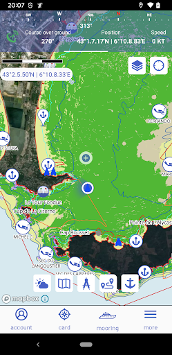
DONIA - Enjoy & protect the sea, together!
Free access to maps of the seabed and up-to-date regulations for a serene anchorage. Anchoring in Posidonia is forbidden and punishable by law.
DONIA is a community marine cartography application for smartphone and tablet. It is intended for yachtsmen, divers, fishermen and all sea lovers who wish to benefit from accurate maps, enriched with data on marine life and real-time information on surface activities.
DONIA is first and foremost a community of enthusiasts who exchange information to make their sea trips easier, richer in discoveries and who want to help protect the environment.
DONIA works and raises awareness of environmental preservation by providing extremely accurate maps of the nature of the seabed, enabling Mediterranean yachtsmen to anchor outside the protected Posidonia meadows.
DONIA also means greater safety on board, whether sailing or motoring. The application proposes to live the traditional maritime solidarity by sharing your anchorage spots, information on biodiversity, dangers seen at sea (obstacles, accidents, jellyfish, etc.).
Finally, DONIA users can receive free information from managers of protected sites (parks, reserves). Practical to avoid tedious procedures and find local regulations easily.
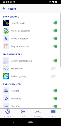
The Premium version of the application (€24.99 per year, €2.99 per month) gives access to new data and navigation features : (1) high definition bathymetric charts to find new points of interest; (2) SHOM (Service Hydrographique et Océanographique de la Marine) nautical charts in the French Mediterranean; (3) regulation and navigation tools (port info, weather prediction heading and arrow, waypoints and measurement tools, navigational tracks) and safety at sea (skid, entanglement and collision alarm pack) ; (4) AIS (Automatic Identification System) data from the AISHUb network; (5) weather forecasts every 3 hours up to +72h; (6) weather preferred anchorage points, (7) community tools.
Please note that continuous use of GPS in the background may reduce battery life.
Conditions of use: http://app.donia.fr/cgu/
The Community application for navigation and anchoring assistance outside fragile ecosystems DONIA is available and used in the Mediterranean.