| نصب | ۳.۸ هزار |
| از ۳ رأی | ۳.۷ |
| دستهبندی | ابزارها |
| حجم | ۴۴ مگابایت |
| آخرین بروزرسانی | ۲۹ خرداد ۱۴۰۵ |
| نصب | ۳.۸ هزار |
| از ۳ رأی | ۳.۷ |
| دستهبندی | ابزارها |
| حجم | ۴۴ مگابایت |
| آخرین بروزرسانی | ۲۹ خرداد ۱۴۰۵ |
تصاویر برنامه


معرفی برنامه
Distance & Land Area Measure app is useful to calculate GPS area and GPS distance with great accuracy. You can use POI to specific point locations. It is fast, simple, and easy to use. You can calculate measurements by GPS measurement and manual measurement.
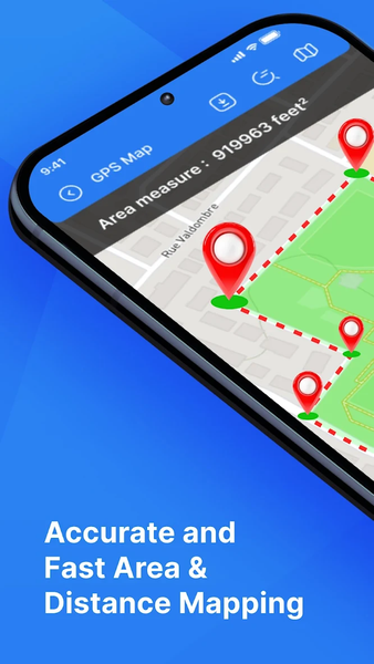
If you can measure any place or place area on a map by sitting at your current location using this Distance and Land Area Measure app simply select the area you want to measure on the map.
This application helps to calculate the distance between two or more points anywhere on the earth. In this, you can also choose the places from where you want to calculate the distance.
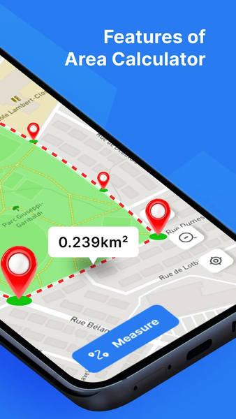
For area and distance calculations, you just click on the map to place the first marker and then click again to position the second marker, through this you can mark the places you want to calculate. If you mark any wrong point you can delete it. You can even zoom in on the locations if you want.
If you want to save the measurement field after the calculation is complete, you can save it by entering the measurement name and measurement description. You can also add images from the camera and gallery.
POI- In the place of interest you just select the locations and it will show you the latitude and longitude of the selected locations. You can even save it.
In that application, the map can be changed to normal, satellite, terrain, or hybrid. You can also edit saved measurements. Plus, import your measurements in KML and KMZ. Search easily for the desired location in it.
Saved: All measurements are save in the Saved folder of the app. In this, you can easily find your save area and distance measurement.
Main Features:
* Easy and simple way to measure the size of any area
* Land Area Measure to determine the perfect size of any land and area
* Easy to import any measurement files from your device
* Area measurement with manual measurement and GPS measurement
* Easy to point to any area on a map and find instant details about area measurement
* Save, edit, and change any pointed area by using editing tools
* Save all measurement files by importing photos
* Find the distance between two places user manual and GPS measurement tool
* POI with manual measuring and GPS measuring
* Latest features such as zoom in, zoom out, point of view, undo button and one click to save
* Convenient way to change the map type with normal, satellite, terrain, hybrid
* Fast area distance measurement tool
* Real time measuring and calculating between two points
* Calculate fast and reliably with high accuracy
* Easy way to drag and drop points on a map with a simple touch
* Save your measure in detail by importing instant photos from the gallery and camera
* Nice app with a clear User Interface design
